Infographic / Edu Visual - Point Nemo Infographic prompt
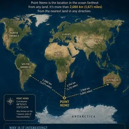
An educational infographic detailing Point Nemo, the oceanic pole of inaccessibility, showing its location relative to continents and interesting facts about its remoteness.
by Generated Atlas·CC-BY-4.0 license·via YouMind (CC BY 4.0)·Source ↗
Use now
Real results
1 image made with this prompt
Posted publicly by the author. AgentAlley did not make or edit these images. Click an image for the original.
| 1 | Goal: Create an educational infographic explaining {argument name="topic" default="Point Nemo, the most remote place on Earth located in the ocean"}. |
| 2 | |
| 3 | Canvas: Vertical portrait layout with a deep navy blue background and a subtle starry night sky texture at the top. The style is clean, modern, and informative, using gold and white text for high contrast. |
| 4 | |
| 5 | Layout: |
| 6 | 1. **Header:** Large serif title "THE MOST REMOTE PLACE ON EARTH IS IN THE OCEAN" (with "IN THE OCEAN" highlighted in light blue). Below it, a small introductory paragraph defining Point Nemo as the location farthest from land, mentioning the distance of 2,688 km (1,671 miles). |
| 7 | 2. **Central Map:** A stylized world map centered on the South Pacific Ocean. Continents are rendered in muted earth tones (greens, browns) against dark blue oceans. Labels include NORTH AMERICA, SOUTH AMERICA, EUROPE, ASIA, AFRICA, AUSTRALIA, and ANTARCTICA. |
| 8 | 3. **Data Visualization:** A bright yellow dot marks "POINT NEMO" in the ocean south of Easter Island. Three dashed yellow arrows radiate from this point to the nearest landmasses, labeled with distances: "2,688 km (1,671 miles)" to Antarctica, "2,754 km (1,711 miles)" to South America, and "2,966 km (1,843 miles)" to Australia. |
| 9 | 4. **Info Box (Left):** A rectangular box with a compass icon containing the coordinates "48°52.6'S 123°23.6'W" and the nickname "oceanic pole of inaccessibility." |
| 10 | 5. **Bottom Section:** A section titled "WHY IS IT INTERESTING?" with three columns featuring icons and text: |
| 11 | - Icon: Satellite dish. Text: "It's the farthest point from any land, making it the most isolated place on the planet." |
| 12 | - Icon: Space station/satellite. Text: "Spacecraft and the International Space Station use it as the safest place to reenter or drop objects." |
| 13 | - Icon: Ship. Text: "It's so remote that the closest humans are usually astronauts — not sailors." |
| 14 | 6. **Footer:** A concluding statement next to a globe icon: "Point Nemo shows us that even in our well-explored planet, there are places more remote than anywhere on land." |
| 15 | |
| 16 | Visual Style: Professional infographic design. Use clear sans-serif fonts for body text and serif fonts for headings. Ensure the map projection clearly highlights the isolation of the central point. |
Discussion
Alternatives
Anime celMake Japanese TV-anime style videos (MP4) with code — cel-shaded characters with tapered line art, big detailed eyes, hair clumps with a specular band, comedic anime reactions (sweat drop, anger vein, sparkle eyes, ≥< eyes, dot eyes, tears), painted skies with cumulus clouds, school/street/classroom/rooftop sets with time-of-day palettes, speed/focus lines, impact frames, dramatic zooms, smears, sakura petals and anime subtitles (CJK). Canvas 2D rendered frame by frame in headless Chrome, encoded with ffmpeg. Use when a reference video or brief calls for anime / 動畫 / 日系動畫 / アニメ / cel-shaded / slice-of-life / school romance / shōnen-style reactions, or when the video-clone router picks the anime-cel style. 2D only; characters are original (Hina, Ren) or new ones built on the same rig.Lemo opuscarDirect and produce a short film made entirely in code, in one of the styles of the Lemo-Opuscar library (e.g. Impasto Oil Painting 油画厚涂, Watercolor Brush 水彩笔刷, Ukiyo-e 浮世绘, Satellite Briefing 卫星简报, Exploded Teardown 产品拆解, Microscope Story 显微叙事). Use when the user asks for a video, film, short, promo, explainer or animation (视频、短片、动画、宣传片) in a named style, including data, science and product explainers built from real material such as satellite imagery, laser scans, CAD files or archive scans (数据解说、科普、产品拆解); when they want a film made about their own topic and haven't chosen a style (help them choose); or when they ask which film styles there are. Not for editing or converting existing video files.Xiaohei illustrationsGenerate Ian-style Xiaohei illustrations for articles, posts, blogs, Notion documents, workflows, methods, processes, structures, states, metaphors, and opinions. Use when the user asks for weird, hand-drawn, Xiaohei, article, editorial, body illustrations, illustration ideas, shot lists, title removal, image edits, or image regeneration. By default, all image text and annotations are English, even when the source article is Chinese; only use another language when the user explicitly asks. Scenario game assetsUse when creating game art through Scenario MCP: sprites, sprite sheets, icons, props, loot, tilesets and autotile terrain transitions, seamless tiles, isometric buildings, top-down maps, pixel art, UI buttons and panels, parallax background layers or depth planes for side-scrollers, and character or concept art; or when assets need transparent backgrounds, background removal, style-consistent variation batches, upscaling, pixel-grid cleanup, or PNG export for Unity, Godot, or Unreal.
Browse more free AI prompts or everything in Content creator.